
Tropical Storm Erin: A Potential Major Hurricane on an Uncertain Path
This article details the formation and forecast for Tropical Storm Erin, the fifth named storm of the Atlantic season.
WEATHER
Muhammad Atique
8/12/20254 min read
Tropical Storm Erin Churning in the Atlantic:
A Closer Look at the Season's Fifth Named Storm
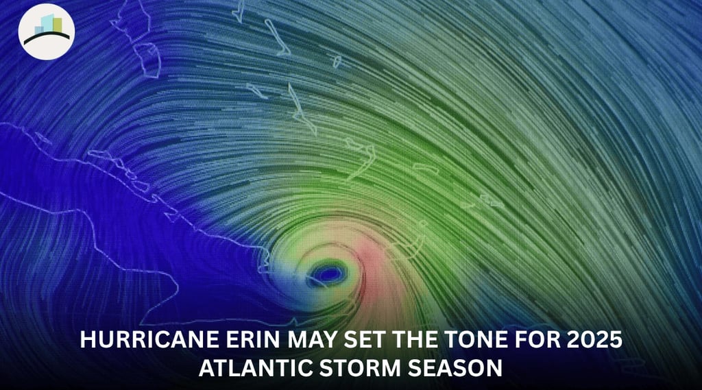
As Erin makes its way across the open waters of the eastern Atlantic, all eyes are on its potential to become the first hurricane of the season and even reach major hurricane intensity by the weekend. While the storm is still more than 1,800 miles from the northern Leeward Islands, its future path remains a critical point of focus for forecasters. People living along the coast, from the Caribbean up to the U.S. The East Coast has been advised to monitor the storm's progression closely, as its longer-term future is still uncertain.
Erin's Formation and Projected Intensification
Tropical Storm Erin officially formed on Monday in the eastern tropical Atlantic Ocean, just west of the Cabo Verde Islands. By Monday afternoon, the storm was tracking westward at 20 mph and had maximum sustained winds of 45 mph. According to forecasters, Erin's initial path will be a westward trajectory, with a gradual bend to the west-northwest later in the week.
This path is significant because it will lead the storm into increasingly favorable conditions for strengthening. Erin is benefiting from a lack of disruptive wind shear and is moving over warmer-than-average ocean temperatures, both of which are favorable for its development. These two ingredients are critical for a tropical cyclone to intensify. As a result, forecasters believe Erin could reach hurricane strength as early as Wednesday night or Thursday. A tropical storm becomes a hurricane when its maximum sustained winds reach at least 74 mph.
The storm’s intensification may not stop there. There is a possibility that Erin could become the first major hurricane of the season by the weekend, potentially reaching Category 3 strength or higher as it moves just north of the Caribbean islands.The development of Erin is a clear sign that the Atlantic hurricane season, which runs from June through November, is entering its peak months of August, September, and October.
Potential Impacts and Long-Term Uncertainty
While Erin is not an immediate threat to the U.S., its potential impacts are already a consideration for islands in the Caribbean. Even if the storm’s center passes north of the northern Leeward Islands, it could still deliver some significant effects. Coastal areas may experience high surf and dangerous rip currents, while bands of heavy rain and gusty winds could sweep across the islands this weekend.
The storm’s path after it moves past the Caribbean is where the long-term uncertainty lies. The forecast models indicate that the system will begin to turn more to the north sometime between this weekend and early next week. This turn is expected to be influenced by a developing break in high pressure, with one high-pressure system positioned over the Southeast U.S. and another located east of Bermuda. The storm's exact trajectory will be determined by where this northward turn occurs, a detail that forecasters are still working to pinpoint.
This uncertainty is the reason why interests along the U.S. East Coast, Bermuda, and Atlantic Canada are being urged to continue monitoring the storm. While the probability of a direct strike from this system along the U.S. East Coast is considered low at this time, it is far too early to rule out any possible track scenarios for next week. The situation is dynamic and requires continuous updates as the forecast becomes more focused in the coming days.
A Busy Season in the Atlantic and Pacific
Erin is the fifth named storm of what has been a busy Atlantic hurricane season. This year’s activity began just over two months ago, and there have already been some notable systems. Earlier this season, Tropical Storm Chantal made landfall on the Carolina coast, bringing deadly flooding to the region. Last week, Tropical Storm Dexter formed in the western Atlantic, but it did not pose a threat to land. The National Weather Service predicted an above-normal season for the Atlantic basin, forecasting an expected number of named storms between 13 and 18, with five to nine of those potentially becoming hurricanes.
As tropical activity heats up in the Atlantic, a look at the Pacific Ocean reveals a similar pattern. This year, the Pacific has already seen the development of six hurricanes. Hurricane Henriette, a Category 1 storm, strengthened well away from Hawaii but was not expected to make landfall. The remnants of a former Tropical Storm Ivo were also being monitored but were not expected to pose a threat to land.
The new activity in the Atlantic comes at a time when many residents are beginning to get back to their normal routines. In South Florida, two of the largest school districts in the U.S., Students in Miami-Dade County are expected to return later in the week. The timing serves as a reminder that hurricane season is a constant presence during these months, and preparedness is a necessity.
A storm is classified as a tropical storm, hurricane, or major hurricane depending on its wind speed. A tropical cyclone becomes a tropical storm once its maximum sustained wind speeds reach at least 39 mph. It is upgraded to a hurricane when its sustained winds hit 74 mph. Hurricanes are rated on a scale ranging from Category 1 to Category 5, with a major hurricane defined as a storm that reaches at least Category 3 strength, with sustained winds of 111 mph or more. For now, Erin is on the lower end of that scale, but its potential for rapid intensification means that its status could change dramatically in a matter of days.