
Hurricane Watch: Invest 97L and a Humid Week in Sarasota
This article details the status of a developing tropical system, Invest 97L, in the Atlantic that is showing a high probability of becoming the season's first hurricane, Erin.
WEATHER
Muhammad Umaish
8/11/20253 min read

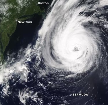
Forecasters are closely watching a tropical system in the Atlantic this week, known as Invest 97L, which appears to be intensifying. Located in the eastern Atlantic, this system is a prime candidate to become the season’s first hurricane in the days ahead. While early computer models suggest a path that could turn it north before reaching Florida, meteorologists are exercising extreme caution, as it is simply too early to guarantee a safe passage. The development of this storm, which would be named Erin, serves as a powerful reminder that hurricane season is in full swing, and its presence is already influencing the local weather patterns in Sarasota.
The Genesis of a Potential Hurricane
The storm's origins are tied to a cluster of showers and thunderstorms that emerged from the African coast last week. Over the weekend, this cluster organized into a tropical rainstorm near the Cabo Verde Islands. Experts from the National Hurricane Center and AccuWeather are in agreement: conditions are ripe for this system to continue strengthening. Several factors are working in its favor, including a lack of disruptive wind shear, a minimal amount of dust in the atmosphere, and exceptionally warm ocean waters—all of which are perfect ingredients for a storm to intensify.
According to the National Hurricane Center, Invest 97L has a high probability of developing into a tropical depression or storm this week. Should it continue to evolve, it is expected to reach hurricane strength by late in the week, making it the first hurricane of the 2025 season. With the average date for the first hurricane of the season being August 11, this storm's potential development is right on pace. While the immediate impact on the U.S. is not a concern, the system is bringing locally heavy rain and gusty winds to the Cabo Verde Islands as it begins its westward trek across the Atlantic. For that region, AccuWeather has rated the storm a less than one on their RealImpact™ Scale, signifying that while it is a notable weather event, it is not expected to be a major disaster.
A Cautious Forecast for the U.S.
The long-term path of Invest 97L is being closely monitored by meteorologists while it makes its journey across the Atlantic. While some early models suggest a turn northward, steering the storm away from Florida and the East Coast, forecasters are not yet ready to make that a definitive call. AccuWeather Senior Meteorologist Chad Merrill points out that the upper air pattern late in the week favors this northward turn, which would likely keep the storm east of the U.S. seaboard. However, this is not a guarantee.
Even if the system remains far from land, it could still affect coastal areas. A strengthening storm in the Atlantic could lead to an increase in rough surf and dangerous rip currents along East Coast beaches as the weekend approaches. For residents and visitors, this means that even a distant hurricane can pose a significant safety risk. As the week unfolds, every new piece of data will be critical in providing a clearer picture of the storm’s trajectory. Farther out in the north-central Atlantic, a second disturbance is also being monitored, but with only a 20% chance of development over the next week and no threat to land, its development is not a cause for concern at this time.
The Local Weather Story: A Wet and Sizzling Week
While the primary threat of Invest 97L is a future concern, the moisture it has helped to fuel is already impacting the local weather in Sarasota. The muggy, tropical air hanging over the region is the perfect fuel for afternoon thunderstorms, making it feel like a "warm, wet blanket." If you could squeeze it all out, that number would be the depth of the resulting puddle. Early this week, the number is running at over 2 inches, which is an exceptionally "juicy" amount of moisture for storm development. As the week progresses, that number is expected to drop slightly to around 1.7 to 1.8 inches, a change that will have a notable effect on storm activity.
This drop in moisture, combined with slightly warmer air high in the atmosphere, will make it more difficult for storms to grow tall and strong. The result will be fewer large thunderstorms, and those that do form will not last as long. This trend toward slightly less stormy weather should be noticeable as the week progresses toward Friday.
The Sea Breeze and What Lies Ahead
A subtle shift in the sea breeze's typical behavior is forecast. Friday’s forecast shows a weak westerly component to the breeze, which will tend to keep storms right along the coast in the afternoon instead of pushing them inland and moving back toward the coast by late afternoon.
Even with slightly lower rain chances, residents should not put away their umbrellas. Any storms that do form could still produce heavy rain, frequent lightning, and gusty winds, posing a threat to anyone caught outdoors. The forecast remains dynamic, and if Gulf moisture returns a bit sooner than expected, weekend storm coverage could end up being higher than currently predicted. Throughout the week, expect highs to stay in the low to mid-90s, keeping conditions consistently hot.