
Hurricane Erin: A Storm of Historic Intensification and Widespread Threat
This article details the powerful journey of Hurricane Erin, a storm that made history with its explosive and rapid intensification to a rare Category 5.
WEATHER
Muhammad Umaish
8/17/20253 min read
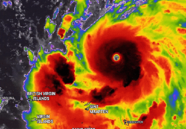
A powerful and unpredictable Hurricane Erin is making history as it churns through the Atlantic. While it is currently rated as a Category 3 hurricane with maximum sustained winds of 125 mph, its recent behavior has sent a powerful message to meteorologists and coastal residents alike. Over the weekend, the cyclone underwent an explosive transformation, briefly becoming a rare Category 5 storm before weakening and expanding in size. It is currently passing north of Puerto Rico and the Dominican Republic, and while it is not forecast to make landfall on the U.S. mainland, its impact will be felt far beyond its immediate path.
A Historic Display of Rapid Intensification
What has set Hurricane Erin apart from other storms is its astonishingly rapid intensification. In just over 24 hours on Friday and Saturday, the storm's wind speeds surged from a Category 1 with 75 mph winds to a Category 5 with winds of nearly 160 mph. This incredible power surge has placed Erin in the history books as one of the fastest-strengthening Atlantic hurricanes on record, and potentially the fastest to reach that intensity so early in the season. The storm rapidly grew in strength after forming, a process that National Hurricane Center Director Mike Brennan described as “explosive.”
It makes forecasting more difficult and gives coastal communities less time to prepare for an incoming storm. The increasing frequency of these events in the Atlantic is widely attributed to climate change, as warmer oceans and a warmer atmosphere provide the fuel necessary for hurricanes to intensify rapidly. Erin's sudden and extreme strength is viewed as a stark example of the increasing extremes of a warming world. Its brief time as a Category 5 also makes it part of a troubling trend, as it is the 11th such storm to form in the Atlantic since 2016, a remarkably high number. This marks the fourth consecutive Atlantic hurricane season to feature at least one Category 5 storm, a clear sign that the peak strength is becoming more attainable for these weather systems.
Immediate Impacts and Broader Dangers
As Hurricane Erin churns through the Atlantic, its effects are already being felt across the Caribbean. The outer bands of the storm have brought heavy rainfall to the northern Leeward Islands, the Virgin Islands, and Puerto Rico, with rainfall totals predicted to reach up to 6 inches in some areas. This has led to an increased risk of storm-related hazards, including flash flooding, landslides, and mudslides. Authorities issued a flash flood warning for northern Puerto Rico, advising residents to be vigilant.
Further north, tropical storm warnings are in effect for the Turks and Caicos Islands, where strong winds and dangerous rip currents are anticipated. The US Coast Guard has restricted port traffic in the US Virgin Islands and Puerto Rico—including the major port of San Juan—as a result of the region's gale-force winds.
Even as the storm passes north of the Caribbean islands and begins to turn away from land, its expansive windfield will create dangerous conditions far from its center. The National Hurricane Center has warned that Erin will generate life-threatening surf swells and rip currents along almost the entire US East Coast, as well as in the Bahamas and Bermuda. Dangerous surf is predicted to be most severe along the coasts of Florida and the mid-Atlantic states. Even Atlantic Canada could see hazardous surf conditions as the storm progresses.
The Forecast and a Troubling Trend
As the storm begins to veer away from the US, its forward speed has decreased. The NHC expects it to continue its north-northeast curve, moving into the open Atlantic and passing between the East Coast and Bermuda next week. As it does so, forecasters believe Erin could undergo an eyewall replacement cycle, a process that could cause the storm's wind field to expand in size, potentially doubling or tripling its current reach. While this would cause its central wind speeds to fluctuate, it would make the hurricane an even larger, more formidable system. The storm is expected to persist for several more days before slowly weakening.
According to the National Oceanic and Atmospheric Administration (NOAA), Hurricane Erin’s remarkable characteristics are a powerful example of what is expected to be an “above normal” Atlantic hurricane season. This storm, with its historic rapid intensification and rare strength, serves as a powerful reminder of the increasing power and unpredictability of hurricanes in a warming world.