
2025 Atlantic Hurricane Season: The Paradox of a New Storm
This article explores the unusual trends of the 2025 Atlantic hurricane season, focusing on the formation of Tropical Storm Dexter
NEWS
Muhammad Atique
8/5/20254 min read
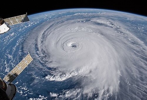
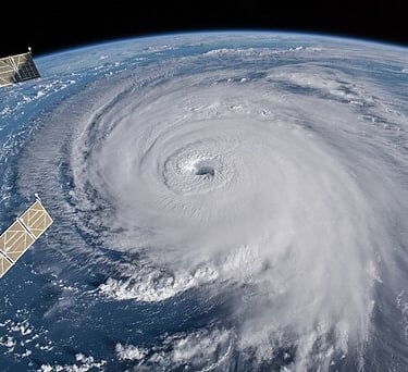
Hurricane Dexter and the Unpredictable 2025 Atlantic Season
The 2025 Atlantic hurricane season, an ongoing natural event that officially began on June 1 and is set to run until November 30, has already proven to be a period of meteorological intrigue. While these dates historically encompass the vast majority—roughly 97%—of all tropical and subtropical cyclone formation in the Atlantic, this year’s season has been marked by a series of unusual developments. The latest of these is Tropical Storm Dexter, which has joined the roster as the fourth named storm, hinting that the season is now entering what is typically its most active phase. However, Dexter’s formation has also continued a perplexing trend of short-lived, weak storms that have been a hallmark of the season so far.
The Genesis and Fuel of a Short-Lived Storm
Tropical Storm Dexter, which developed from a stalled weather front roughly 300 miles northwest of Bermuda, was named on the night of August 3, 2025. The storm's formation occurred ahead of the season's usual schedule. By August 4, it was tracking toward the east-northeast at a speed of 12 miles per hour, generating persistent wind gusts of up to 45 miles per hour. While these wind speeds classified it as a tropical storm, they fell well short of the 74 miles per hour required to be a Category 1 hurricane.
One of the most striking characteristics of this season is the high temperatures of the ocean water. The Atlantic is currently registering temperatures approximately 1.5°C (2.7°F) above average, a condition that typically provides the ideal fuel for tropical systems to strengthen. The presence of warm water is the primary energy source for hurricanes; it provides the moisture and heat that are converted into the powerful winds and heavy rainfall associated with these storms. This would lead one to expect a robust storm, yet Dexter was predicted to last for only three days despite these seemingly favorable conditions. The combination of warm ocean water and short-lived storms presents a fascinating and somewhat paradoxical meteorological puzzle that scientists are closely monitoring.
A Season of Weak Storms and Deadly Consequences
A similar pattern was seen in the first named storms of the 2025 Atlantic season, which were Andrea, Barry, and Chantal. They were weak and short-lived, with each lasting an average of just 2.5 days. Despite their lack of long-term power, their impact was tragically significant. The remnants of these storms caused deadly flooding in North Carolina, claiming six lives. This serves as a stark reminder that a storm's official classification or longevity does not always correlate with its potential for harm. Even a short-lived tropical system can bring devastating rainfall and life-threatening conditions, particularly in coastal and low-lying areas. The events of this season so far underscore the critical importance of preparedness and heeding all weather advisories, regardless of a storm's perceived strength.
Historically, the first hurricane of the season is expected to form around August 11. However, this year, meteorologists are predicting a delay in the formation of the first official hurricane, a forecast that seems to be in direct contradiction with the unusually warm ocean temperatures. This meteorological anomaly is a subject of ongoing study, but it is believed that other atmospheric factors, such as wind shear or broad-scale atmospheric instability, may be counteracting the The energy from the warm water is being offset by factors that inhibit the formation of stronger tropical cyclones.
Monitoring the Horizon: A Shift to a More Active Period
Even as Tropical Storm Dexter dissipates, the National Hurricane Center is closely monitoring two new areas of possible development, signaling that the season is poised to become more active. This shift is a key part of the seasonal forecast and aligns with the typical intensification of hurricane activity in late summer and early fall. The two areas of concern are located along the Southeast U.S. Coast and in the Central Atlantic.
The first area is a weak low-pressure system expected to develop later this week near the Southeast U.S. Coast. While the chances of this system developing into a full-fledged tropical storm are only around 30%, it is still a significant weather event. The system is expected to bring heavy rainfall to parts of Florida, Georgia, and South Carolina. Such rainfall can easily lead to flash flooding and coastal erosion, creating dangerous conditions for residents and visitors alike.
The second area of concern is a tropical wave in the Central Atlantic, which is expected to develop late in the week. This system has a relatively higher chance of development, with a 50% probability of becoming a named storm. Its projected path is particularly noteworthy, with forecasts suggesting it could move toward the Bahamas or the U.S. East Coast rather than entering the Caribbean. If both of these potential storms were to form, they would be named Erin and Fernad, respectively, continuing the alphabetical naming convention of the season.
Weather trader meteorologist Ryan Maue stated that the season is "moving into a more active period." This sentiment is echoed by many in the meteorological community, who believe the unusual atmospheric and ocean conditions in 2025 are creating the potential for a very active period of the season.
A Call for Continued Vigilance
The 2025 Atlantic hurricane season has, from the start, been a lesson in unpredictability. From weak storms causing significant damage to the perplexing delay of the first hurricane, the season has defied easy classification. As new systems brew in the Atlantic, the call for continued preparedness and monitoring of official forecasts is paramount. The warm waters that have been a feature of the season so far may yet fulfill their potential to fuel more powerful storms. With the season's most active period on the horizon, residents of coastal communities must remain vigilant.